|
|
Multiposition Synthetic Aperture Radar (MPSAR) Alexander V Ksendzuk |
| Main Page |
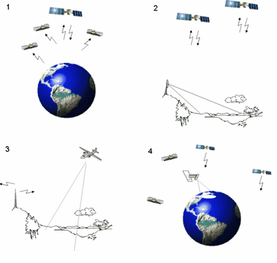
9. Pseudo-passive SAR. Multiposition synthetic aperture radar will be pseudo-passive when it consists of elements which really not part of the MPSAR. Usually it is transmitters ¢ FM stations, communication and navigation satellites etc. Therefore to create pseudo-passive multiposition SAR we need to launch receiver (receivers). Main advantage of this system which utilises scattered from the surface signals (which was emitted by other radioelectronic systems) is low costs of creation. Possible configurations of the pseudo-passive SAR shown in Figure 9.1:
Figure 9.1. Possible configurations of the pseudo-passive SAR 1 ¢ satellite-transmitter and set of receivers may be used for increasing functionality of the existing monostatic SAR; |
||||
| Signal Model | |||||
| Geometry | |||||
| Optimal Signal Processing | |||||
| Object detection | |||||
| Multiposition SAR interferometer | |||||
| Pseudonoise signals in remote sensing systems | |||||
| Remote sensing systems modeling principles | |||||
| About Author | |||||
| Links | |||||
|
2 ¢ stationary receiver with satellites-transmitters (communication, navigation) may be used for ecological/change control of the certain area; 3 ¢ aerial receiver which uses signals of the ground stations (TV, FM) 4 ¢ satellite-receiver which uses signals of other satellites-transmitters (communication , navigation satellites) Here we analyse Multiposition SAR, which uses GPS/GLONASS signals to image earth surface. Considered multiposition system consists of one receiver (special avionic or space sensor) and navigation satellites constellation. Possibility of the GPS signal usage for remote sensing was investigated in a great number of papers but there we concentrate on processing methods when all (or almost all) visible GPS/GLONASS satellites uses for imaging. Moreover there considered optimisation of the remote sensing experiment which allow to achieve maximal quality of the images for known transmitters position (suppose we will use almanac). 9.1. Signal-to-noise ratio Any measuring system (particularly remote sensing system) works with presence of the noise. Measurement accuracy (for example, exactness of the surface parameter estimation) strongly depends on signal-to-noise ratio (SNR), energetic, not power. For the radar system it is recommended to fit at least 10-12 dB SNR. Consider signal in the antenna is an addition of the scattered electromagnetic field and additive noise; processing algorithm - matching filtering; signal-continuous (GLONASS/GPS navigation signal). In this case output of the estimator will be
where
With equation (1) signal-to noise ration in the output of the matched filter will be
After some transformations (consider aperture synthesis time more than 0.1 sec) the last equation may be written as
where
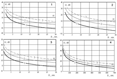
As an example SNR as a function of the receiverÆs range over surface and space resolution (25š25, 50š50 and 100š100 corresponds to curves 1-3 on each image) were calculated for the aircraft. The results are shown in Figure 9.2. During modelling was considered time of the synthesis 1 sec; real antenna aperture 2X0.5 meters; surface - grassland.
Figure 9.2. Signal-to-noise ratio (curves 1-3 on each image corresponds to spatial resolution 25š25, 50š50 and 100š100 meters) for aerial receiver (altitude 5-25 km) image 1 - 4 visible GPS/GLONASS satellites; image 2 - 8 visible GPS/GLONASS satellites image 3 - 12 visible GPS/GLONASS satellites For satellite receiver (altitude 100-600 km) image 4- 12 visible GPS/GLONASS satellites Therefore, as we can see from the modelling results existing configuration of the navigation satellites (GPS, GLONASS and future GALILEO) allow to make radar image of surfaces with high/medium resolution with aerial receivers and medium/low resolution with satellite receiver. 9.2. Spatial resolution and space ambiguity functions As was mentioned above, space ambiguity function (SAF) is one of the essential characteristics of the remote sensing system.
Normalized SAF (
where
More complicate definition of the MPSAR space ambiguity function is given by equations (5.6), (4.17) in section 4. Multiposition SAR. Optimal signal processing. In this section we will concentrate on visual representation of the ambiguity functions of the Multiposition SAR, which utilises GPS/GLONASS signals.
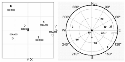
Figure 9.3. Spatial configuration of the GLONASS (left) and GPS (right) system.
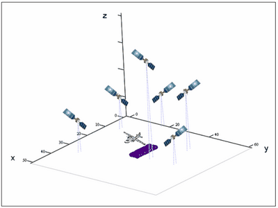
As we can see from the modelling results, GLONASS standard code allows to achieve resolution about 150X40 meters, GPS standard code allows to achieve resolution about 80X40 meters. When military code will be used, resolution will be significantly higher. 9.3. Optimisation of the remote sensing experiment When we use own satellites we can achieve maximal quality of the achieved images by configuring spatial configuration, signals etc (for details see section 3. Multiposition SAR. Geometry and section 7. Signal Groups in Multiposition SAR ). Here we will consider only results (based on previous investigation - sections 3,7) of this optimisation. Consider experiment with given spatial configuration of the GPS satellites (this means that experiment will be done at certain time and date and we know position/velocity of the satellites). We need to select viewzone (direction of the view) of the aerial SAR which utilises scattered from the surface GPS signals, Figure 9.6. Other optimisation may search for the best aircraft position/velocity for imaging of the certain area, selection of the date/time (and therefore selection of the GPS constellation) ¢ but results of these optimisation not so ōclearö for understanding.
Figure 9.6. Spatial configuration of the optimised Multiposition SAR (transmitters -GPS satellites, receiver placed on aircraft). Gradient optimisation (for details see section 3. Multiposition SAR. Geometry) allow to select zone in which spatial resolution and signal-to-noise ratio will be appropriate. Results of gradient optimisation are shown in Figure 9.7.
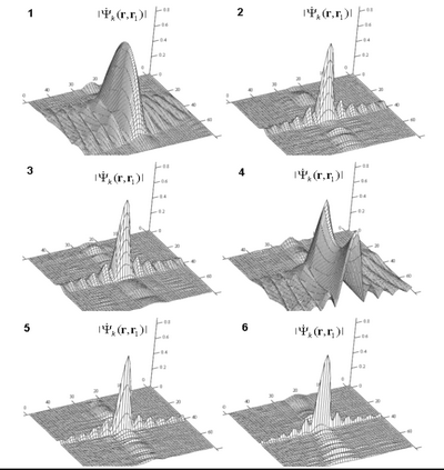
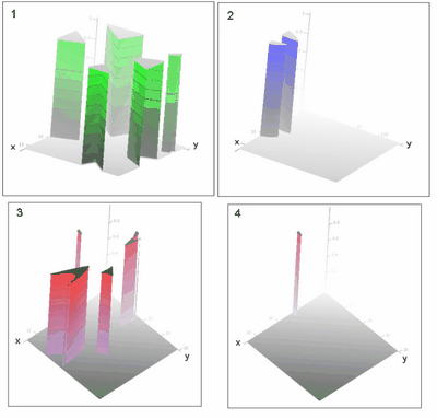
Figure 9.7. Results of Gradient optimization ¢ area with acceptable resolution and SNR Images 1,2 - based on absolute gradient values in range (1) azimuth (2)
Image 3
- based on angle between gradients Optimisation results for the same spatial configuration which takes into account interchannel errors and surface model (dependence of the radar cross section on bistatic angle) are shown in Figure 9.8. (for details see section 7. Signal Groups in Multiposition SAR ).
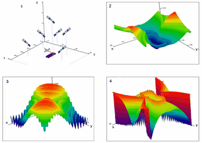
Figure 9.8. Spatial configuration Image 1 - Spatial configuration of the optimised Multiposition SAR Image 2 - Signal-to-noise ratio as the function of the surface coordinates (calculations takes into account interchannel interference) Image 3 - model of the surface model (dependence of the radar cross section on bistatic angle) Image 4 ¢ signal-to-noise ratio as the function of the surface coordinates (calculations takes into account interchannel interference and surface model) Examination of the achieved results shows that signal-to-noise ration may changes in 4-8 time into surface. Selection of the viewzone ¢ area in which SNR is maximal allows to provide higher possible SNR. Combination of this result with gradient optimisation (Figure 9.7) allows to select viewzone in which not only SNR but spatial resolution will be maximal. Conclusion. Navigation systems GPS/GLONASS as well as future system GALILEO may be used for remote sensing of the surface with high and medium resolution. With standard code spatial resolution will be about 150X40 meters for GLONASS and 80X40 meters for GPS system. Military codes (high accuracy codes) allows too increase spatial resolution. Remote sensing experiment with GPS/GLONASS satellites must be optimised, because corresponding SNR in surface changes in 4-8 times and unproper experiment may results in bad data (noisy and/or low-resolution).
|


|
e-mail to author: Alexander V Ksendzuk |